Sort Score
Result 10 results
Languages All
Labels All
Results 1,851 - 1,860 of 55,622 for

as

(0.07 sec)
  1. DocumentRecoveryMode enumeration | Aspose.Words...

    Aspose.Words.Loading.DocumentRecoveryMode enumeration. Specifies the available recovery options when a document encounters errors during loading....Aspose.Words.Loading.DocumentRecoveryMode enumeration. Specifies the available recovery options when a document encounters errors during loading.

    reference.aspose.com/words/nodejs-net/aspose.wo...
  2. Document.stop_track_revisions method | Aspose.W...

    Document.stop_track_revisions method. Stops automatic marking of document changes As revisions....Document.stop_track_revisions method. Stops automatic marking of document changes as revisions.

    reference.aspose.com/words/python-net/aspose.wo...
  3. Export EML to DOCX via C++ | products.aspose.com

    C++ API to Convert EML to DOCX without using Microsoft Word or Outlook...C++ API to Convert EML to DOCX without using Microsoft Word or Outlook

    products.aspose.com/total/cpp/conversion/eml-to...
  4. DocumentBase.warningCallback property | Aspose....

    DocumentBAse.warningCallback property. Called during various document processing procedures when an issue is detected that might result in data or formatting fidelity loss....DocumentBase.warningCallback property. Called during various document processing procedures when an issue is detected that might result in data or formatting fidelity loss.

    reference.aspose.com/words/nodejs-net/aspose.wo...
  5. Add WordArt Watermark to Chart with Golang via ...

    Learn how to use Aspose.Cells for C++ to add a WordArt watermark to a chart in Microsoft Excel. Our guide will demonstrate how to create and position a WordArt watermark to enhance the visual appeal and uniqueness of your chart....Learn how to use Aspose.Cells for C++ to add a WordArt watermark to a chart in Microsoft Excel. Our guide will demonstrate how to create and position a WordArt watermark to enhance the visual appeal and uniqueness of your chart.

    docs.aspose.com/cells/go-cpp/add-wordart-waterm...
  6. DRC Drawings|CAD Documentation

    ClAss Libraries & REST APIs for the developers to manipulate & process Files from Word, Excel, PowerPoint, Visio, PDF, CAD & several other categories in Web, Desktop or Mobile apps. Develop & deploy on Windows, Linux, MacOS & Android platforms....Class Libraries & REST APIs for the developers to manipulate & process Files from Word, Excel, PowerPoint, Visio, PDF, CAD & several other categories in Web, Desktop or Mobile apps. Develop & deploy on Windows, Linux, MacOS & Android platforms.

    docs.aspose.com/cad/net/developer-guide/cad-and...
  7. FieldLink.insert_as_bitmap property | Aspose.Wo...

    FieldLink.insert_As_bitmap property. Gets or sets whether to insert the linked object As a bitmap....FieldLink.insert_as_bitmap property. Gets or sets whether to insert the linked object as a bitmap.

    reference.aspose.com/words/python-net/aspose.wo...
  8. PageInfo.PaperTray | Aspose.Words for .NET

    Discover the PageInfo PaperTray property to access the specific paper tray bin for your document. Enhance your printing efficiency with tailored solutions!...Discover the PageInfo PaperTray property to access the specific paper tray bin for your document. Enhance your printing efficiency with tailored solutions!

    reference.aspose.com/words/net/aspose.words.ren...
  9. GIS and Geo Formats for Effective Data Management

    The overview covers commonly used GIS and Geo file formats in GIS applications, including vector data formats, rAster data formats, web map formats, databAse formats, and other formats. It discusses popular formats such As Shapefile, GeoJSON, KML, PostGIS, Oracle Spatial, Microsoft SQL Server Spatial, GPX, NTF, Mapbox Vector Tile, SVG, TopoJSON, and OGC GeoPackage. This information helps readers choose the appropriate format for their geospatial data and optimize their GIS applications....The overview covers commonly used GIS and Geo file formats in GIS applications, including vector data formats, raster data formats, web map formats, database formats, and other formats. It discusses popular formats such as Shapefile, GeoJSON, KML, PostGIS, Oracle Spatial, Microsoft SQL Server Spatial, GPX, NTF, Mapbox Vector Tile, SVG, TopoJSON, and OGC GeoPackage. This information helps readers choose the appropriate format for their geospatial data and optimize their GIS applications.
    products.aspose.com/gis/net/gis-formats/
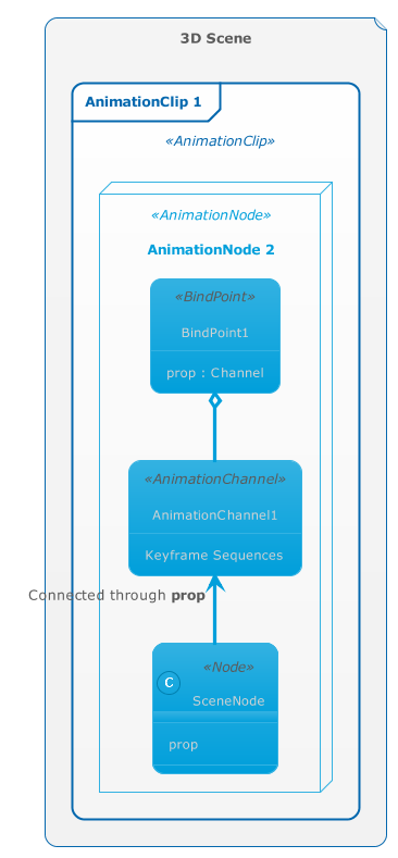
  10. animation_relations.png

    nonpremultipled deflate 789 8 8 8 8 PixelInterleaved width=366, height=789, bitDepth=8, colorType=RGBAlpha, compressionMethod=deflate, filterMethod=adaptive, interlaceMethod=none RGB 8 8 8 8 789 ke......nonpremultipled deflate 789 8 8 8 8 PixelInterleaved width=366, height=789, bitDepth=8, colorType=RGBAlpha, compressionMethod=deflate, filterMethod=adaptive, interlaceMethod=none RGB 8 8 8 8 789 ke...

    docs.aspose.com/3d/it/net/aspose-3d-document-ob...